Saturday, March 8, 2014
Behind The Scenes Long Narrow Garden
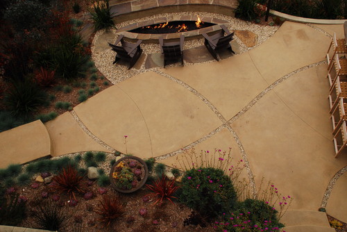
 About 10 years ago, there was nothing but grass and weeds around this old church building. We used to mow mainly weeds every couple of weeks in order to keep the place tidy, but it never did ever really look tidy.
 Initially we talked about extending the paved areas around the back of the building, but to do this as cost effectively as possible we needed to re-use the existing brick pavers. We bought some basic concrete flagstones, and used the brick pavers to add some detail. The large squares created, helped to reduce the scale and minimise the feeling of narrowness of the area down the side.
The next area that we tackled, was the weedy area on the other side of the building. The plan was to convert it into a low maintenance garden. The church building created a little bit of a problem, as it sheltered the area from the prevailing winds and therefore the rain. To solve this, we sloped waterproof sheeting into the areas that tended to remain dry. This would in effect, cause rainwater to run into the areas that would not get much natural rain.

We cut holes in the sheeting, and planted up the area with succulents, and other low maintenance indigenous plants. To hide the sheeting we spread decomposed granite over the top, and in between the plants.


The last requirement was an area for the children to play in. We considered planting grass, but this would have required weekly cutting, and in such a small area, the likelihood is that the grass would never have looked very good. Eventually a fine gravel was spread over the relatively small area. This was not the ideal solution either, as the children took great delight in using the small stones to block up the drains, and spread them around. It was also not the softest landing for children if they fell, but in lieu of anything better this was the option we stuck with.

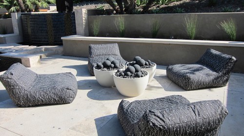
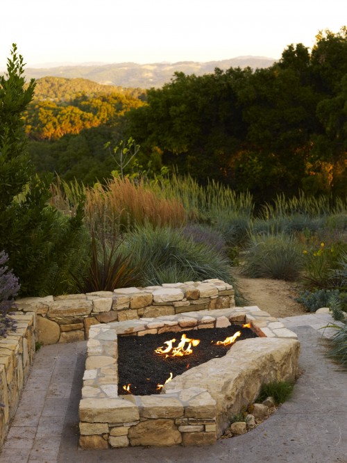
Top Trends in Outdoor Living
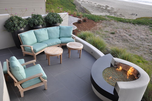
There are several ways we bring the outdoors inside in order to gain a sense of nature, serenity, color and fragrance to our homes. We cut flowers, we plant small herbs and we can make frames from tree branches. But how do we bring a little life to our outdoor living space from non-living things? Fire pits, water features and stonework are a great way to add some flare, interest and spark to your backyard.
According to an article highlighting some local landscapers from Dayton, Ohio, here are the latest most popular trends in outdoor living:
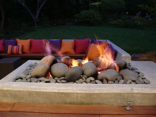
1) FIRE PITS “The hottest trend in the industry right now is the additions of fire pits to outdoor living areas,” said Patrick Flanagan, landscape manager and designer at Knollwood Garden and Landscaping Center in Beavercreek. “They are tough to beat for adding long-term interest and lots of great memories."

Fire pits are the hottest commodity this spring as homeowners and businesses are embracing the idea of outdoor entertainment areas. Extending the season, custom fire pits are great for bar and restaurant patios as well as residential landscape design. Seating areas around fire pits are perfect gathering spots to entertain family and friends. Another advantage a fire pit can offer is that they help you extend both the spring and fall seasons. You can enjoy the outdoors earlier and later in the year by staying warm by the flame of an outdoor burning system.
2) WATER FEATURES “Fountains have gained in popularity because the flowing or trickling water provides serenity and gentle motion to the garden setting and an escape from reality,” said Marybeth Taggart, advertising manager for Grandma’s Gardens and Landscape in Waynseville. “After a hard day at work or just to wind down after a stressful day, a visit to a lush garden with a relaxing fountain is like having a spa in your own backyard.”
From simple pools and ponds, to flowing streams and even waterfalls, the motion and soothing sound of a water feature will create a relaxing atmosphere in your outdoor space. Water equals serenity in landscape design. Make sure you consult with a landscape professional before you try to install your own water feature as they can be complicated and costly if not done properly.
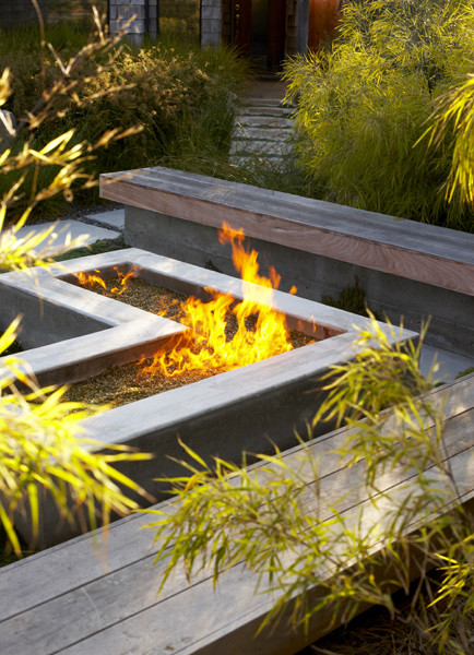
3) STONE WORK & BOULDERS
(This particular landscape design incorporates all three trends to create this backyard haven.)
“Adding boulders to your landscaping is a great way to give it a natural structure. Boulders can be a single accent, or they can be installed as a natural-looking retaining wall complete with plant pockets,” Dorton said.
Stone work brings the natural shapes, contours and curves of nature into your landscape design. Flagstone pavers work well for patios and pathways to tie sections of your backyard together and also act as durable and long-lasting seating areas.
So when you are ready to investigate one or all of these hot landscape design concepts, please visit us online or contact us today and well be happy to help answer any questions you may have. 1-877-556-5255
Friday, March 7, 2014
Gardens are Strange
"The fact that human beings create such things as gardens is strange, for it means that there are aspects of our humanity which nature does not naturally accommodate, which we must make room for in nature’s midst. This in turn means that gardens mark our separation from nature even as they draw us closer to it, that there is something distinctly human in us that is related to nature yet is not of the order of nature…"
Robert Pogue Harrison - Gardens: An Essay on the Human Condition
LANDSCAPE EDGES


1. Form and Fabric in Landscape Architecture; Catherine Dee.
2. Introduction to Landscape Design; John Motloch
3. A Pattern Language: Alexander/Ishikawa/Silverstein.
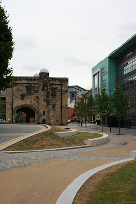
De Montfort University Business School Leicester

I’m currently about half-way through Owen Hatherley’s excellent, “A guide to the new ruins of Great Britain.” At some point, I might write more about it, but given my recent lack of blog activity, it’s perhaps unlikely. The book picks up on a number of issues that have been nagging me about recent regeneration projects; fills them out, gives some historical perspective, adds some critical analysis, and then takes the piss.
As I read the book, it was schemes like the new, De Montfort University Business School, that sprang to mind. Owen describes how many recent buildings have much in common with the “Googie” architecture of 1950’s America; burger joints and giant advertising hoardings, designed to catch the eye of speeding motorists.

With it’s “look at me” turquoise cladding, jauntily angled towards the ring-road vista, this building definitely fits this description. Not wishing to linger too long on the architecture, I find the building slightly tacky and overbearing, particularly given it’s location in Leicester’s historic, Roman heart. While I don’t entirely dislike the plastic-Ikea styling, I resent the way it towers over the nearby Magazine, a solitary vestige of Leicester’s pre ring-road old town.


Naturally, I’m more interested in the landscape treatment and public realm design. Prior to visiting, I’d actually heard some positive comments about the scheme and the quality of finish. Unfortunately, I found it to be a jumbled mess of generic materials, that have little relationship with anything other than the new building. Dark granite pavers, light granite cobbles, buff bound gravel, polished stainless steel, black powder-coated steel, matt grey steel, grass, semi-mature trees, timber, rendered brick, concrete copings, granite blocks and pre-cast concrete, all scattered along a series of unrelated axis and geometries.


I would imagine that there was some sort of design statement which explained how the materials were inspired by the dirty sandstone of the magazine, unfortunately it would be empty post-rationalisation for the use of the same old materials palette and the simplest, polyline-from -the corner-of-the-building, design approach. Yes I’ve seen the same materials used elsewhere, by the same designers and on more than one occasion.
It’s funny, but I think there are clear parallels between recent public realm designs, with overly busy, multi-materialled treatments and much of the post-millennium architecture of Britain. I’m not sure if I’ve ever seen a provincial arts centre built in the last 5 years that didn’t feature a riot of cladding treatments. However, I’ve not seen anyone comment on how this fad has spread to the world of landscape architecture.


Returning to this particular scheme, I’m also irritated by the half-arsed detailing that is prevalent. Yes, it can be a bugger to get this stuff right, but all you need is someone who cares enough to see that service access’ doesn’t interrupt the design intent.

I REALLY hate the way, granite blocks meet a chamfered precast concrete block. Perhaps I’m being harsh on the designers involved and maybe this detailing is the result of some contractor led, design and build/value engineered approach. I really, really hope so.


Perhaps the most successful element of the scheme, is the area around the old Arts’ School building, leading up to the old Gateway College (yes I went there). The palette of materials seems much more restrained, with a formal lawn and some fine mature trees. However, I was a little dismayed that the treatment ends so abruptly before reaching the Gateway building.


Similarly, the paving doesn’t extend right up to the adjacent Newark House Museum (unsurprisingly the only bit of the area not part of the mighty, De Mont). In fact, for some reason we actually have a guard rail impeding access to this entrance?!?


Finally, the scheme also includes a ubiquitous, courtyard, come-amphitheatre, come performance space, complete with some tasteful planting. It’s quite pleasant.


Okay, okay, have I been too harsh on this scheme? In isolation, its not so awful. Im really trying hard not to be the blogging equivalent of Statler & Waldorf. Certainly, it’s much better than what used to be there, and I daresay that students will really use all that space to congregate, drop flyers and enjoy the odd hand rolled cigarette. The materials are at least of good quality, and for a certain sort of person, the scheme does give a certain veneer of urban sophistication. I just wish it was better.
Perhaps, given the inevitable quiet time ahead, it would be a good idea for us all to reflect and what actually makes a good public space and how successful the recent glut of schemes have actually been. Or maybe we should step away from ‘statement’ schemes, be they architecture or landscape architecture, and get back to improving the quality of our streets, homes and public amenities.
Thursday, March 6, 2014
Unique Fire Pit Designs
We here at Warming Trends are always building unique and custom fire pits for our clients all across the country and North America. We are always interested in seeing new designs to offer our customers ideas for their homes and businesses. Below are a number of unique fire pit designs we have found on the internet or actually built for our clients.

Custom Teardrop built by Warming Trends

Custom Fire Pit built by Warming Trends
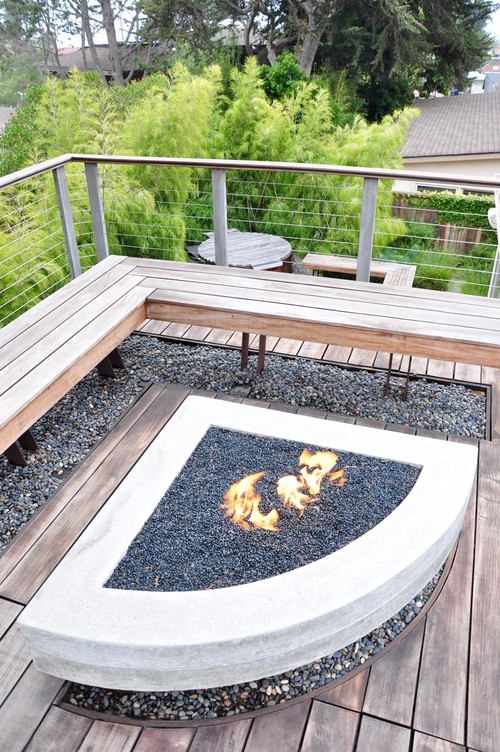

Custom Fire Pit built by Warming Trends
When you are in the market for a custom fire pit, please dont hesitate to contact us online, or call today. 1-877-556-5255.
The Answer is Blowing in the Wind
roof garden + high winds = hard, scary work
Landscape PLANNING Part 3
British public parks resemble a 1960s nationalized industry. They suffer from:
bureaucratized management
falling consumer appeal
insensitivity to users
under-investment
bad planning
bad design
no data
So what can be done?
The first requirement is data. It needs to relate to each park and to include information on user numbers, landscape quality (scenic, historic, ecological
etc), management expenditure and capital expenditure.
The data should be entered in a Geographical Information System (GIS), analysed in different ways and used to guide planning, design and management decisions.
Users must become involved in park management. This can happen in many different ways, according to the characteristics of the park: user groups, sponsorship,
consultative committees, trust ownership, user involvement in maintnenace work.
Parks should be diversified, according to the characteristics of the local environment, the ways in which users want to use the space and the resources
which can be obtained.
Public Parks: from monoculture to multi-culture
Tom Turner (as published in Local Government News 1998)
Park development is an aspect of property development. It differs only in that the land tends to be un-roofed and in public ownership. The same principles
apply to making or re-making an urban park as to other types of property development. They are generally listed as:
Location
Location
Location
These principles are put to work when, for example, a supermarket chain obtains land for a new store or re-develops an existing store. Commercial planners
analyse supply and demand. For example:
Retail Analysis is used to learn about the current availability of goods in the locality.
Postcode Analysis is used to determine the characteristics of the local market.
Origin and Destination Analysis is used to predict how customers will reach the store.
Regrettably, the same level of expertise is not applied to the planning and management of public open space in urban areas. Leisure Services Departments
are not good at working with Town and Country Planning Departments. The situation in Britains parks, in 1999, compares to that of a badly run nationalised
industry in 1959. Our parks suffer from under-investment, falling consumer appeal and a management approach which appears rigid and out of touch. Management
lacks data. This matters ten times more than a lack of cash. But take heart. In the last 5 years most local authorities have acquired the computer software
which supermarkets use for retail planning: GIS.
Currently, the main uses for GIS in local government are map management, holding records of planning applications and the managing public open space maintenance
contracts. Since the hardware, the software and the map data have been purchased, there is a great opportunity to used GIS techniques to manage the data
required for public parks. Two types of data are necessary: about demand and about supply.
Demand Analysis can be conducted by means of social surveys and Postcode Analysis. Postcode Data is available from market research firms, at a price, or
free over the internet from http://www.upmystreet.com. The data is aimed at house buyers but it provides an overview of the socio-economic groups in a
parks catchment. Some of the other data which might be used is shown on the Public Open Space Planning Chart (Fig 1). Amongst other indicators, the chart
uses BBC Radio stations to characterise cultural groupings. A Radio 4 park, for example, might have demonstration gardens and text panels explaining what
can be seen. A Radio 1 park would have ephemeral displays and venues for popular sports.
Supply Analysis requires surveys of existing public open spaces in a municipality. According to a recent report on Public Open Space Planning and Management
with GIS, the most important measures are use intensity, maintenance expenditure, scenic quality, nature conservation quality and historic quality. Comparative
data should be assembled and entered in the GIS. This will provide management with the information which is necessary for effective decision making (Fig
2). It might be found, for example, that Park A has high use intensity and low scenic quality, while Park B has low use intensity but a high maintenance
cost. This could lead to a well founded policy of increasing the nature conservation value of Park B, by shifting from amenity management to habitat creation,
and of increasing the scenic quality of Park A by investing in capital works.
Taking an overview of the parks in a locality will facilitate a shift away from monoculture. It is as bad for the urban landscape as it is for the farmed
landscape. We need a great diversity in open space types and in management methods. This could produce specialist parks to reflect the nature of late-twentieth
century society. We have a surfeit of semi-Victorian parks with playing fields, shrubberies, bandstands, childrens play areas, kidney-shaped ponds and
drab bedding. Our heritage of Green Parks can be supplemented with Pocket Parks, Nature Parks, Food Parks, Red Parks, Blue Parks, Yellow Parks, White Parks,
Age Parks, Political Parks, Ethnic Parks, Flood Parks, Air Conditioning Parks, Museum Parks, Art Parks, Religious Parks and Radios 1 to 5 Parks. But no
decisions should be made until the necessary management information has been assembled.
Captions:
Fig 1 Parks should be diversified. This park planning chart shows a range of options. One set of choices has been ringed, for an urban fringe park.
Fig 2 The cover of Public Open Space Planning and Management with GIS shows a set of diversified parks, interlinked with equally diversified greenways.
Planning the landscape and environmental impact of water storage reservoirs
Many people prefer to live, and enjoy their leisure, beside water. An EID approach to reservoir land could provide many opportunities. Rivers and sea coasts
accommodate visitors during holiday periods, but reservoirs are likely to be near urban concentrations, and their potential for uses in addition to water
supply should be fully developed. Since only a few of these uses can be anticipated when the reservoir is planned, it is necessary to carry out periodic
landscape studies of existing reservoirs. They are a huge man-made resource. The greatest development opportunity in East London is shut away behind the
3m concrete fences of the Lea Valley Regional Park. Investors might like to buy the water companys stock with a view to stripping out their underused
assets.
Old reservoirs have new capabilities
Gathering grounds are a historic example of single-purposism.
Water recreation 1948-1981: Too little and too late.
Water recreation since 1976: The new danger is excess recreational development.
The drawdown problem: It is not a problem.
Reservoir planning: Reservoirs could become urban development zones.
Planning principles: Reservoirs should develop in the context of landscape plans.
Reservoir archetypes: Archetypes are useful in reservoir planning. (Wild reservoirs, Agricultural reservoirs, Urban reservoirs, New town reservoirs)
Reservoir parks: Water is inherently beautiful and desirable.
Forestry reservoirs: Reservoirs and forests can be good neighbours.
Recreation reservoirs: Not all reservoirs need be peaceful.
Childrens play reservoirs: Like drinking water, children need to be safe.
Wild life reservoirs: Reservoirs can assist in habitat creation.
Reservoir archaeology: There are few opportunities to preserve a complete village.
Conclusion The huge potential of reservoirs should be subject to regular review.
Refs
Dangerfield, B.J. 1981. Recreation: water and land. London:Institution of Water Engineers and Scientists.
Turner, T, Landscape planning and environmental impact design. London:UCL Press 1998 Chapter 5
Dam and drawdown at Bewl Bridge reservoir in Kent, England.
Reservoir Policy
Reservoirs should be planned as part of a landscape-wide development programmes for the areas in which they are set.
Since most old reservoirs were planned as exclusion zones, for now-obsolete health reasons, there is a major opportunity to develop reservoir-side land
for other purposes.
Reservoir New Towns would yield many benefits for society and rich rewards for the water companies which own the land.
Reservoirs in towns could provide a type of recreation (ie water recreation) which is much closer to the needs of our own time than traditional urban parks.
Landscape planning for floods: from river engineering to river reclamation
Where are the streams of yesteryear? Underground. (Whyte 1970: 362)
Those streams of yesteryear will have to be reclaimed. They lie imprisoned in underground culverts or restrained by concrete walls and artificial embankments.
Because wild nature is everywhere under threat, we want our rivers back. Drainage works and impermeable surfacing continue apace. Unless drastic action
is taken, all the rivers in the all the urban regions of all the industrialised countries will be lost. This drawing shows the lost rivers of London.
Flood prevention: Floods induce fear - and high expenditure.
Forest clearance: Forest clearance accentuates flooding.
A forest can absorb rainwater, like a great sponge, and help it run into the ground. This benefit is removed when the forest is removed. The current plight
of Bangladesh is a tragic example (Khalil, 1993). At one time there were great swamps and forests in the foothills of the Himalayas. Malaria kept humans
out. After the introduction of anti-malarial drugs, the forest was cleared and the rate of run-off greatly accelerated. Periodically, this causes terrible
floods and loss of life in Bangla Desh [Fig 9.2]. The developed countries which have removed their forests have also increased their liability to flooding.
Axemen have no interest in EID.
Agricultural drainage: Farm drainage accentuates flooding.
Urban drainage: Urban drainage accentuates flooding.
River works in Britain: River improvement accentuates flooding.
Present conditions: The flood problem has been accentuated.
River reclamation And he shewed me a pure river of water of life, clear as crystal, proceeding out of the throne of God and of the Lamb. (Bible Ch 22 v
1, Revelation of St John the Divine)
In the past, improving rivers meant increasing their flow capacity. In future it should refer to multi-purpose schemes designed to improve the capacity
of each river valley to function as a visual amenity, a recreation area, a fishery, a nature reserve, a water supply, a storm detention area, a drainage
network, and a movement corridor for boats, walkers, cyclists and equestrians. We are fortunate that the means have become available:
Multi-purpose planning Rivers can do more than carry water.
Managed flooding Flood risk can be managed.
Storm detention Storm water should be detained.
Rainwater infiltration Storm water should be infiltrated.
Vegetated roofs Vegetated roofs decrease flooding.
Porous pavements Porous pavements decrease flooding.
Natural riverworks Bio-engineering is better.
Robert Louis Stevenson wrote:
Dark brown is the river,
Golden is the sand.
It flows along for ever,
With trees on either hand (R L Stevenson, Where go the boats)
River control structures: River structures should serve many objectives.
Coastal defence: Coasts need landscape plans.
Conclusion We must win our rivers back.
After centuries of improving rivers and defending coasts against floods, the developed countries have given their waterfronts a military aspect, dominated
by embankments, retaining walls, and concrete ditches. A major reclamation programme is necessary to reclaim our channels, water-courses, culverts
and coastal defences. Their dignity must be restored, as streams, brooks, rivers and shores.
At some happy point in the future, it may become possible to follow the melancholy book on The lost rivers of London (Barton 1962) with a triumphalist sequel:
How we won back Londons rivers.
Links
River restoration abstracts 2000
Open Directory section on
River Restoration
Refs
Barton, N. 1962. The lost rivers of London. London:Pheonix House.
Dunne, T. & Leopold, L.B. 1978. Water in environmental planning. San Francisco: W.H. Freeman
Brookes, A. 1988. Channelized rivers: perspectives for environmental management. Chichester:John Wiley.
CIRIA 1992a. Report 124: Scope for control of urban runoff Volume 2: A review of present methods and practice. London:Construction Industry Research and
Information Service.
CIRIA 1992b. Report 124: Scope for control of urban runoff Volume 3:Guidelines London:Construction Industry Research and Information Service.
Gardiner, J.L. 1994. Sustainable development for river catchments. Water and environmental management Vol 8 No 3.
Glitz, D. 1983. Artificial channels - the ox-bow lakes of tomorrow. Garten & Landschaft. February pp 109-111.
Hall, M.J. 1984. Urban hydrology. Amsterdam Elsevier.
Nixon, M. 1966. Flood regulation and river training. In Thorn, R.B. River engineering and water conservation works. London:Butterworth.
Turner, T, Landscape planning and environmental impact design. London:UCL Press 1998 Chapter 9
The River Manzanares, in Madrid, awaits reclamation.
Rivers Policy
A major reclamation programme is necessary to reclaim our channels, water-courses, culverts and coastal defences. Their dignity must be restored,
as streams, brooks, rivers and shores.
Landscape character plans should be formulated.
Rainwater should be infiltrated near to where it falls - or else it should detained near to where it falls, and discharged slowly.
Rivers and coasts should be planned, designed and managed. In places, this will require no human intervention: the coast should be as natural as possible.
In other places, their scenic and recreational potential should be developed. Rivers and coasts have exceptional scope for contributing to a green web
of public open space.
Negative environmental impacts should be mitigated.
Positive environmental impacts should be planned and designed. Waterfront land is our most valuable land.
The concept of Relative Sustainability
To ‘sustain’ means to keep going. When a musical note is played, the meaning is unmistakable. With reference to landscape planning, it is unclear. On a
geological time scale, mountains rise and fall, species evolve and become extinct. The ant has sustained its physical form and way of life for hundreds
of millions of years. What would it mean for a human society to be sustainable? Affordability, Sustainability and Solubility have meaning only in defined
circumstances. Salt is soluble in water but not in oil. A house can be non-affordable for most of us but easily purchased from Bill Gates’ pocket money.
Sustainability makes sense only as a comparative. Labelling one city, or land use practice, ‘sustainable’ and another as ‘non-sustainable’ is meaningless.
The illustration below, reproduced from an essay on Eco-Cities in Tom Turners City as landscape illustrates the concept of relative sustainability. A
city with high inputs (of energy, food, water etc.) and high outputs (of thermal pollution, sewage, vegetable waste etc.) is less sustainable than a city
of the same size but with lower levels of input and output. This usage accords with the circumstances in which the concept of sustainability was introduced,
in the 1970s. The world was thought to be running out of resources. It hasnt happened on the input side. But rich societies’ hatred of pollution has grown
and provides a strong reason for making our towns more ‘sustainable’ in the defined sense.
Improving the relative sustainability of a city requires an evaluation of those features which affect its pattern of inputs and outputs. This is likely
to include earth, water, vegetation, building types, transport systems and spatial organisation. One can then assess the potential for change through landscape
planning. Two of the main challenges are the attainment of sustainable landscape objectives in the densely built city core, which is often historic, and
the need to engage communities in a desire for sustainable cities and the consequent changes that will ensue. The achievement of sustainability objectives,
in cities which were built on less-sustainable principles, is a complex process. The social, physical and biological systems in urban areas are as complex
as natural systems. Sustainability planners need to study, model and make proposals for the urban landscape at all scales and levels, in time and space,
and beyond the usual span of three generations.
Links
UK Green Party policy on
sustainability
Refs
Hough, M., City form and natural process Croom Helm London 1984
Porritt, J. 1984. Seeing green: the politics of ecology explained. Oxford: Blackwell.
Royal Society for the Protection of Birds, 1994 New rivers and wildlife handbook Sandy:RSPB.
Spirn, A.W. 1984. The granite garden. New York:Basic Books.
Benson, J., Roe, M., Landscape and sustainability (Spons, 2000)
Turner, T., Ecocities City as landscape (Spons, 1996)
Sustainability Policy
Relative Sustainability is a more useful concept than Absolute Sustainability.
A city with high inputs (of energy, food, water etc.) and high outputs (of thermal pollution, sewage, vegetable waste etc.) is relatively less sustainable
than a city of the same size but with lower levels of input and output.
Improving the relative sustainability of an urban landscape requires an evaluation of those features which affect the pattern of inputs and outputs. This
is likely to include earth, water, vegetation, building types, transport systems and spatial organisation. One can then assess the potential for change
through landscape planning. Two of the main challenges are the attainment of sustainable landscape objectives in the densely built city core, which is
often historic, and the need to engage communities in a desire for sustainable cities and the consequent changes that will ensue. The achievement of sustainability
objectives, in cities which were built on less-sustainable principles, is a complex process. The social, physical and biological systems in urban areas
are as complex as natural systems. Sustainability planners need to study, model and make proposals for the urban landscape at all scales and levels, in
time and space, and beyond the usual span of three generations.
Transport: from highway engineering to green planning
Transport planning has been dominated by single-purpose planners and civil engineers.
To civilise means reclaim from barbarism.This requires transport. Without it we would have no cities, no mass production, no specialisation, no journeys
to work, no tourism, no modern conveniences. Civil engineering is vital.
But the planning and design of roads, like other modes of transport, tends to become the preserve of blinkered specialists infatuated with the dream of
maximising the transport mode for which they assume responsibility. They ignore other public goods. They neglect EID.
Historic conservation Historic roads are as deserving of conservation as ancient buildings, woodlands and other landscape features.
Adaptation to context Road design must relate to its context, as must the design of buildings and other prominent structures.
Multi-mode transport We can have a far greater range of route-types than at present, and better links between transport modes.
Bridleways Roads were made for horses.
Green residential roads Houses can front onto green roads.
Urban avenues Cities can have new avenues.
Panoramic roads Driving can be a pleasure.
Leisure roads Many journeys, but few roads, are planned for leisure.
Off-roads Off-road driving is enjoyable but can be damaging.
Speed roads Speeding can be allowed in some places.
Roads in public parks They were designed for horses and should carry horses.
Railways Railways require environmental impact design.
Cycleways Cycleways can be beautiful, safe and luxurious.
Skateways Skating is fun.
Canals Canals should not belong to transport agencies.
Footways Pedestrians should be pampered.
Pedestrianisation schemes If the are to succeed, knowledge, imagination and design judgement must be employed.
Traffic calming Traffic calming is a bad name for a good idea.
Streets Bring back the street.
Transport planning Transport modes have to be integrated, with each other and with the environment.
Refs
Hass-Klau, C. 1990. The pedestrian and city traffic. London:Belhaven Press.
McClusky, J. 1979. Road form and townscape. London:Architectural Press.
Buchanan, C.D., 1963 Traffic in towns London:HMSO.
Turner, T, Landscape planning and environmental impact design. London:UCL Press 1998 Chapter 10
Green Transport Policy
Historic roads should be conserved.
Cities need experts in planning for each transport mode (train, car, bus, cycle, pedestrian, horse, skates etc) and experts in the integration of transport
modes.
Provision for cycling should receive budgetry priority.
Citizens should have access to public transport via environmentally pleasant green routes, for walking, cycling, riding, skating or canoeing. The young,
the old, the poor and the dispossessed should have access to public transport or green transport. Well-used walks should enjoy the benefit of visual policing
and should be safe from the dangers of drunk drivers, joy-riders and runaway trucks.
While waiting for a bus or train, it should be possible to sit in comfort, sometimes in the sun and amongst flowers. Coffee and newspapers should be on
sale. There should be a shelter with seats.
Road planning cannot and should not be separated from other aspects of planning. So road designers must think about pedestrians, nature reserves, water
management, recreation, architecture and the noble art of bridge design. They can learn from their medieval predecessors who understood that engineering
to be the exercise of ingenuity.
For the soul, to travel is better than to arrive.
Landscape planning for urbanisation
All the worlds cities are growing - and the quality of urban design in the new areas is deeply depressing. In large measure the problem results from entrusting
the design of each component to specialists - without any serious attention to design of the space between buildings (the outdoor landscape). Highway
engineers design roads, builders and architects design houses and apartment blocks, manufacturers design industrial sheds. Then, at the end of the day,
one might commission a gardener to green-up the space between buildings, with ghastly results. If you want your city to have good open space between buildings,
and on top of buildings, then landscape plans should precede urban development. The principle applies on greenfield sites and in urban renewal and regeneration
projects.
Manifestly, we want access to clean air, sunshine, beautiful cities, sparkling rivers, ancient woods, gathering places in which to encounter other people.
Landscape planners should focus on public goods and EID (environmental impact design). They should be plural in spirit and forward-looking in practice.
This requires knowledge and information. With clear objectives for guidance, as beacons guide ships, we can respond to contexts and prepare plans which
reflect the diverse wishes of diverse groups.
With imagination and skill, land uses can be integrated. Single-use planning is generally bad planning. It causes side-effects and public goods to be neglected,
so that the land uses fall into disfavour and then decay. In this chapter, I have aimed to take a long view of the urbanisation process. While it proceeds,
communities should found new settlements which conserve the existing landscape and create new public goods. Planning is required - but not too much of
it.
At the start of the twentieth century, when optimistic reformers first argued the case for planning, they were confident that state control would produce
a better world, with social justice, green parks, housing set apart from industry, towns ringed by fields, sunny streets, dung-free roads and hygienic
disposal of other waste products. By the end of the twentieth century, some of the dreams had been realised and others had become nightmares. The new cities
had dirty rivers, polluting roads, dreary parks, ugly scenery and dangerous footpaths. The City of Dreadful Night became the City of Dreadful Day.
Planning was part of the problem. In the Soviet Union, government planning produced grim totalitarian cities dominated by wide roads and high blocks, set
far apart. In the United States, government planning took the form of over-investment in roads, rigid land use zoning and under-investment in public space.
Western Europe compromised between these extremes, keeping its ancient town centres but surrounding them with a mix of Soviet and American planned development.
The author of Londons best plan, Patrick Abercrombie, argued that:
When two or three buildings are gathered together, there arises the question of their relationship to each other; when a road cuts across an open stretch
of country, there is its relation to the landscape; when a piece of Land is enclosed, the question of the boundary lines occurs, and the decision as to
the use to which it is put or the manner in which it is divided up. All these are examples of Town and Country Planning (Abercrombie 1959 edn: 11).
Like other modernist planners, he was too hasty in arguing from some to all. Twentieth century planning rested on an invalid argument form:
Some actions by land users affect other land users
All actions which affect other land users require planning
Therefore all actions by land users require planning
To logicians, this is known as the fallacy of the undistributed middle. I prefer the following, valid, argument:
Some actions by land users affect public goods
All actions which affect public goods require planning
Therefore some actions by landowners require planning
Landscape planning can produce settlements which are rich in public goods. We should, as Nan Fairbrother said, make new landscapes for our new lives (Fairbrother,
1970:8).
Urbanisation requires planning.
Finding a good site is the hardest task.
Settlements need parents.
Good decisions rely on good information.
Topography comes first.
Heed the wisdom of the ancients!
Parks rely on contexts.
Earthmoving provides great opportunities.
Streams should be treasured.
owns need lakes.
Towns need community forests.
Roads can spoil towns.
All public is just as bad as all private.
Planning housing areas for a single aspect of the public good tends to produce an unnacceptable degree of uniformity.
Planning commercial projects like fried eggs disregards the public good.
Noxious industries require special zones. Other types of industry do not.
Refences
Turner, T, Landscape planning and environmental impact design. London:UCL Press 1998 Chapter 11
Bacon, E.N. 1967. Design of cities. London:Thames and Hudson.
Ashihara, Y. 1983. The aesthetic townscape. Cambridge Mass:MIT Press.
Krier, R. 1979. Urban space. London:Academy Editions.
Lynch, K.1960. The image of the city. Cambridge, Mass:MIT Press.
Trancik, R. 1986 Finding lost space New York:Van Nostrand.
Whyte, W.H. 1980. The social life of small urban spaces. Washington:The Conservation Foundation, Washington.
Urbanisation Policy
Urbanisation should be preceded by landscape plans.
Manifestly, we want access to clean air, sunshine, beautiful cities, sparkling rivers, ancient woods, gathering places in which to encounter other people.
With imagination and skill, land uses can be integrated.
Communities should found new settlements which conserve the existing landscape and create new public goods. Planning is required - but not too much of it.
Landscape planning can produce settlements which are rich in public goods. We should, as Nan Fairbrother said, make new landscapes for our new lives (Fairbrother,
1970:8).
Re evaluation of work examples and self promotion
I dont believe the sample images I sent out gave an effective picture of the scope of my work. When my Wey and Arun project is complete at the end of the week, I will have a better range of project images and media available. Some companies however (such as West 8 for example) only want hard copies of work so I will need to find a few select images that portray my work more effectively than the ones I had chosen previously (see older posts).
Wednesday, March 5, 2014
The Bees Knees


Not a real bee but a fly - a Bee Fly - Bombylius major, a fast wee fellow who did his best to elude my lens!
Whether a true bumble bee or just a cuckoo bee? Its all in the hairiness of the legs!
The Bumble Bee Conservation Trust has a super helpful identification webpage if you want to get that close!